Alblasserwaard (NL) - Background
Inhoud
Physical environment and background information
Aanwijzing inhoud:
Beschrijving van het gebied (bijvoorbeeld max 400 woorden):
Geografische ligging, stroomgebied, gemeenten, waterlichamen, gebruiksfunctie gebied ...
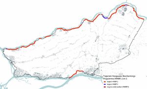
The Alblasserwaard is a polder to the east of Rotterdam, surrounded by dikes. It is confined by the rivers Lek in the north and Beneden Merwede in the south. Smaller rivers and canals surround the west and the east of the Alblasserwaard. The landscape can be described as a peat-grassland area used for agriculture (Waterschap Rievierenland, 2015). There are several small cities in the south of the polder and linear settlements in the center.
Alblasserwaard consist of ten municipalities called: Alblasserdam, Giessenlanden, Gorinchem, Hardinxveld-Giessendam, Molenwaard, Papendrecht, Sliedrecht, Vianen, Zederik en Leerdam. In the area is a lot of cattle breeding, fruit farming, shipyards and dredging industry. Furthermore, the area has two provincial roads and two highways. In addition, a very busy junction called Knooppunt Gorinchem and one train track is located in Alblasserwaard.

Frames Pilotbook (2017)
Demographics of society
Aanwijzing inhoud:
Apply resilience targets:
300.000 inhabitants
2 - 10 communities.
Frames Pilotbook (2017)
Flood risk governance arrangement
Aanwijzing inhoud:
Apply flood risk governance arrangements according to the following dimensions:
- Diversification and dominance of strategies. Dominance of some strategies and arrangements in this countrie? What factors explain further diversification of flood risk governance arrangements?
- Multi-sector governance. Relates to factors that explain why flood risk governance either has more differentiated structures, such as sector-based water management, or relies on integrated planning – or even integrated risk management – and what are the possible changes therein?
- Multi-actor governance. Concerns factors that explain why flood risk governance is a responsibility of the state, the market and/or civil society, their interrelationships, and possible changes therein.
- Multi-level governance. Relates to factors that explain why flood risk governance is organised locally, regionally, or nationally, what possible shifts in (de)centralisation we see, and how we can explain them.
----------
Alblasserwaard
Low diversification, defence dominant. Water sector is dominant. De public (state) is dominant. Central en regional level.
Buijs, J-M. (2018)
Vragen/discussie:
Moeten we hier ook de informatie uit de enquête (FRAMES_Monitoring_Survey_1_Alblasserwaard_Completed.pdf) gebruiken? Hier staan soms wat opmerkingen bij de toelichtingen van de scores.
Nog even goed nadenken wat we met dit kopje beogen en moet duidelijk onderscheid hebben met de 2 paragrafen hieronder
Challenges for flood resilience
Vragen/discussie:
Moet hier vooral informatie over de problematiek in het gebied rondom waterveiligheid?
Nog even goed nadenken wat we met dit kopje beogen en moet duidelijk onderscheid hebben met de andere paragrafen
National Adaption Strategy (NAS):
The National Waterplan comprises climate adaption strategies to protect the Netherlands from (coastal and river) flooding, to work towards climate resilient urban areas and to ensure adequate supplies of freshwater for generations ahead. The waterplan is implemented by the National Delta programme.
How can MLS improve the NAS and local / regional / national activities?
The National Water Plan states that the measures required to comply with the updated flood safety standards must be realized before 2050. The National Water Plan's preferred strategy for achieving the flood safety standards is the MLS approach.
Buijs, J-M. (2018)
Current situation
Vragen/discussie:
Nog even goed nadenken wat we met dit kopje beogen en moet duidelijk onderscheid hebben met de andere paragrafen
Ik vermoed dat de paragrafen nog iets specifieker en meer onderscheidend moeten zijn. Bovenstaande paragrafen gaan toch over current situation?
In 2017 there are new norms for the water safety in the Netherlands. These new norms are set down in the new Deltawet that is included in the Deltaprogramme of 2017. At this moment, there are some projects about strengthening the dikes. Between 2030 and 2050 the dikes must be strengthened on different places because these dikes do not meet the new norms, this is basically for the whole Alblasserwaard area. This problem is related to the second and third layer of the multi-layer safety approach. The multi-layer safety approach is an approach that reduces the possible damage to areas and make sure that people can evacuate effective by a natural disaster, mostly flooding’s.
In Alblasserwaard is already a solution for the first layer, but this solution is not enough, this solution distract the view of some people’s home’s for example so there have to become solutions in other layers to solve these problems. About the second layer, there are not spatial adaptation measures already implemented. For example, there are a lot of houses build next to dikes, the dikes cannot be strengthening further because it will damage the houses, by searching spatial adaptation measures, it is possible to find solutions for these problems. About the third layer, there is a lack of evacuation possibilities. Because there are not evacuation plans, this makes it difficult to evacuate if there is a real disaster. (De gemeenten in Alblasserwaard/Vijfheerenlanden, 2016). In this research proposal, the demarcation is set as the second and third layer. The problem is related to the whole area of Alblasserwaard, so the focus of this research will be on the whole area, in figure 2 is the whole area described and in figure 1 is the location of the area described. It is not possible to make a solution for one area within Alblasserwaard, because they all have the same problems and relate to each other.
Bron: Student Reports V3
References
- Adaptive planning for flood resilient areas: dealing with complexity in decision-making about multilayered flood risk management, Buijs, J-M., Boelens, L., Bormann, H., Restemeyer, B., Terpstra, T., HZ University of Applied Sciences, 1 januari 2018.
- Frames pilots, Interreg, Interreg, 1 april 2017.